For me the spring tour over the Sierra has been a way to start the summer since 1958
when I rode with a friend to Sacramento along the river and up Donner Pass (7239 ft). We
rode partly on the newly completed I-80 while traffic was still using US-40. It was early,
so there was plenty of snow as we rode around the west shore of Lake Tahoe to find that
Luther Pass (7749 ft) was still snowed in. Not to be deterred, we hiked over the snow to
Picketts Jct at HWY 88 and rode into Markleeville. We undertook several more such
adventures on that trip and many since. This was a good beginning to a great tradition
that others have taken up, although under the unfortunate title of "Markleeville
death rides".
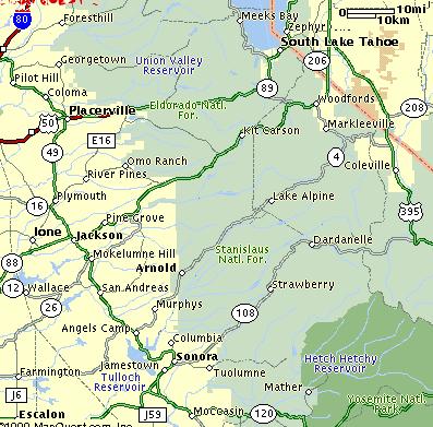
There are three routes across the Sierra that can be connected into two day tours with
the start and finish at Sonora. These are Tioga pass to the south, Sonora Pass in the
middle, and Ebbetts pass to the north. Once, more than ten years ago, I and three other
riders (Bill Henner, Tom Ritchey, Jim Westby, and I) did the "Big Loop", riding
over Tioga Pass in Yosemite Park and returning over Ebbetts pass on a two day weekend
ride. This entails riding over Tioga (9960 ft), Conway (8138 ft), and Devils Gate (7519
ft) passes, 168 miles to Walker on the first day. The second day is no slouch either
crossing Monitor, Ebbetts, and Pacific Grade for 114 miles. This is in contrast to making
the trip over two adjacent passes. To make up for any other advantages, both Tioga and
Ebbetts require crossing the 1000+ ft deep canyons of the Tuolumne or Stanislaus rivers
near Sonora.
This weekend, 12 and 13 June, I set out to try something I had thought about over the
years. I would attempt the "Big Loop" clockwise. As I started alone from Sonora
just before 6 AM, I ran into Bruce Hildenbrand (rec.bicycles.racing) who was driving to
the start of his ride counterclockwise over Tioga. Whether he or I had any plans on a big
loop was not mentioned, and for my part, I felt it could have been self defeating and
presumptuous. We talked a bit of the Giro d'Italia and our slipping US heroes, wished each
other well and got going.
My route from Sonora (1796 ft) rose to Columbia (2143 ft) only to descend to Parrotts
Ferry bridge (800 ft) across the Stanislaus River and back up to Valecito and Murphy's
(2110 ft). The river gorge was still in the purple shadows of morning with the first rays
striking the north shore. There was practically no traffic until I got farther up HWY 4 to
Arnold, where the pickup truck traffic began to get heavier. There were more
"mountain men" than you could count, driving their jacked-up pickups on large
knobby tires. I even saw one Power Wagon that had been converted to tandem rear wheels
with matching long fenders. At Calaveras Big Trees (4000 ft), the dogwood was in bloom and
water was rushing in every stream and brook. It was a pleasant surprise to meet Dave Prion
of Ritchey Bicycles, who was on a fishing trip, as he pulled over to say hello and offer
me some breakfast.
In the cool morning air the gradual climb went easily and, as I got higher, the
vegetation and trees changed. Now at Dorrington (4860 ft) there were ponderosa pine as
well as red and white fir with wild iris along the road. Red and white breasted nuthatches
were making their usual mini duck calls in the forest. Stellars jays and clarks
nutcrackers yacked away and I could see snow on the ridge to the south. At Bear Valley
(7030 ft), Velo Promo was putting on the annual criterium with good organization but
hardly any participants.
I got a pastrami sandwich in the Deli and rode on past the Mt Reba ski area to Alpine
Lake, where the road becomes narrow, forsakes its center stripe, and reverts to a more
primitive asphalt. At the esses a disappointed racer joined me up to Pacific Grade summit
(8050 ft) with its grand panorama. Mosquito Lake, that sits right on the summit, was still
frozen but had a few openings with window pane clear ice from the night. The air was
pristine and clear because the campsites were still snowed in so there was no one burning
Oscar Meyer products (the essence of camping).
Beyond Pacific Grade, the road makes a steep winding descent into Hermit Valley
crossing roaring cascade of Pacific Creek to level off at the Mokelumne River. With
practically no traffic, the road was more like a private bike path. The grand landscape
with wildflowers and crystal clear water was inspiring as I rode up to Ebbetts Pass (8730
ft) and down past Kinney Reservoir that was also still frozen. Clarks nutcrackers gave
their raucous call as they watched the fishermen along Silver Creek for handouts. Some
cyclists with a follow van were making their way up the east slope as I rolled down toward
Markleeville. I stopped at a sparkling cold stream and ate a couple of bananas tanking up
for the climb from the east fork of the Carson River (5700 ft) up Monitor Pass (8314 ft)
over to the Walker river valley (5000 ft).
The view on the descent to Topaz stretches to Nevada with snow capped mountains and the
desert beyond, while below the rich green meadows are wet with Sierra water. Although many
rivers flow into Nevada no rivers flow out of the state. As I rode south to Walker (5400
ft) I felt a favorable breeze that I had noticed along the Carson River. I got a snack at
the grocery store and thought about the wind and the climb to Devil's Gate.
It was still early in the afternoon so I headed into the canyon of the West Walker
River where the wind was disappointingly mild... but it got better. As I approached Sonora
Pass junction (6950 ft) I was cruising uphill easily. After the junction,however, the road
curves around a mountain and, for the next mile or so, I faced a headwind before once
again heading south to Devil's Gate (7519 ft) with its reddish volcanic sentinels. The
wind was brisk now and, on the gentle 5% descent toward Bridgeport, I reached unusually
high speeds for such a mild slope.
Three miles before Bridgeport (6465 ft) the road turns left and straight into town
exposing me to a brisk side wind that came from about 5 to 10 degrees from ahead. I didn't
hurry because that only wastes energy. The strength of this wind gave me other ideas for
the day's goal as I saw yellow headed blackbirds and western gulls among the cows in the
marshy fields that typify Bridgeport. Once in town I downed a chocolate milkshake and a
large Coke just as Bruce Hildenbrand rolled in looking not too happy. He had just fought
stiff headwinds for the last 30 miles, partly while climbing Conway Summit. We discussed
the state of affairs and he encouraged me to take advantage of the wind and go to Lee
Vining where he had seen four friends of mine who were heading in the same direction,
after crossing Sonora Pass.
As I left Bridgeport I rolled along with little effort at near 30 MPH as a group of
about 20 Harley Davidsons rolled by headed toward town. The wind carried the rumble and
rhythmically throbing beat of the huge engines, long after they had passed. By the time I
reached the base of the climb the wind had dwindled to a light breeze. It was getting late
as I crossed the summit at 6 PM. As I tucked in for the smooth descent a MTB rider in a
Jeep Cherokee motorpaced me down the sweeping four lanes of Conway Summit (8138 ft) to the
bottom of the hill at the highest speed I had seen in a long time. From there it was a
casual ride down to Mono Lake before the final 300 ft grunt up to Lee Vining (6780 ft). I
rode right to Nicely's Cafe (it was 7 PM) where I found my bikie friends ordering dinner.
I joined them just in time to place my order. Fortunately I could share their cabin
because there were no vacancies anywhere in town. I had ridden 171 miles and climbed 18150
ft and with the great dinner, I slept well in the cool high mountain air.
We got a 6 am breakfast at Nicely's and, because Bruce had told me that the Tuolumne
Meadows store was not yet open, I ate two breakfasts so that I could make it the 92 miles
to Groveland for the next food. The climb to Tioga Pass (9960 ft) went briskly with cool
breezes and brilliantly clear air. On the way up I saw a western Tanager and a mountain
bluebird at close range, both of these brilliant birds are uncommon in my area. At Ellery
Lake (9489 ft) the road flattened out and a mile later before entering Yosemite Park we
stopped at the Mono Inn for a snack.
We took a group picture at Tioga Pass (9960 ft) and cruised down the long gradual
descent to Tuolumne Meadows (8900 ft). A couple of sharp bumps got us over to the Merced
river watershed and Tenaya Lake. Although the climb from breakfast to the summit was only
3180 feet the descent to Sonora involved at least 6000 feet more climbing that became
evident as the road reached the heat of the San Joaquin valley.
From Crane Flat the old Big Oak Flat road (one way) descends steeply through the
Tuolumne big trees to the Big Oak Flat entrance station. This road was still closed for
repairs so there was no one beyond the Big Trees camp grounds, a mile down the road. The
giant redwoods are always larger than I remember them and the forest, with blooming
dogwood and rushing water, is good for the psyche. At the entrance station I got a couple
of Sodas and rolled on down toward Groveland. My friends, who had stopped at the Crane
Flat Store, caught up to me after the third crossing of the south fork Tuolumne River. My
speed was not up to theirs and I encouraged them on their way as they rolled past me up
the gentle grade. There were still some major bumps before Groveland.
It was hot in Groveland (2844 ft) and I wasn't much for solid food so I put away a milk
shake and some Pepsi and buried an ice cold Pepsi in the clothing in my touring bag for
the 642ft climb out of Wards Ferry on the Tuolumne River. After that, the road continues
to climb gradually to Tuolumne City Rd (2450 ft) and a cold drink would come in handy.
Swallows and white throated swifts were busy darting around loading up on insects over the
river, between the vertical rock walls, at the Wards Ferry Bridge.
The narrow twisting road climbs steeply up the canyon wall to the cliffs directly above
the bridge. Here, I discovered years ago, there was a watering trough under a tree on the
outside of the curve where the road levels off. I dunked my head and wet down my jersey.
The faucet also has good drinking water. I didn't waste this opportunity and rode with a
cool jersey on up to where the road levels off before I dug into my bag for the secret
weapon. The Pepsi was still crisp and cold, and as I drank, the fast guys went by looking
good as they rode to the top of the last major rise where we all regrouped for the ride
into Sonora. This, the second day, was 110 miles and 9280 ft of climbing for a total of
282 miles and 27430 ft.
It was a big trip and I was glad to have caught the opportunity to make the "Big
Loop" of which I had wondered whether it was possible. It is, and it's a great ride.